
When an errand run leaves you scanning unfamiliar neighborhood blocks for an open bathroom, a free phone app can help you locate public restrooms nearby before the urgency truly hits.
This guide by Insiderbits introduces Flush and walks you through how to turn any city street, rest stop, or highway detour into a place where relief is easily available on the map. Read on!

4.7/5
Which is the best free app to quickly locate public restrooms nearby?
Flush (Android | iOS) is a pocket guide to public bathrooms, starting on a map that marks the nearest ones to you and pulling from a database of 200,000+ toilet records worldwide.
Pan or zoom the map to any area along your planned route, and you can locate public restrooms there before you arrive, even in cities and towns you’ve never visited.
The interface takes cues from Material Design, and its smooth animations and transitions keep each screen pleasant to use while you scan the map for a spot worth walking to.
Key features within Flush
- Fee, key and access tags: the app shows you which toilets charge a fee, require a key, or offer disabled access whenever the app has that data;
- Instant directions: tap the directions button and the app routes you to the closest toilet through Google Maps, with no address to type and nothing to search;
- Offline searches: the listings live on your phone, which keeps results available in tunnels, rural stretches, parking garages, and any spot where your cell signal drops;
- Rate and report: slide any toilet in the results list to the left to rate it or flag a mistake that you spot in its details.
Free to use with no in-app purchases
The app costs $0 to download and has no in-app purchases on either the iPhone or Android version, which means every feature you’ve read about works without a payment from you.
Both store listings flag ads inside Flush (Android | iOS), and they appear on screen while you locate public restrooms, which makes them the only cost you’ll run into when using the app.
Limitations to keep in mind before relying on it
Some entries send you to businesses that have closed down, private homes or neighborhood pools reserved for residents, and the app also overlooks some restrooms that do exist nearby.
Flush (Android | iOS) doesn’t display opening and closing hours or the date anyone last confirmed a listing, and many pins mark bathrooms inside shops that expect a purchase.
Step-by-step: how to search for public toilets
Using Flush (Android | iOS) starts with an install, a location permission prompt, and a map that does most of the searching for you, whether you carry an iPhone or an Android phone.
The best time to set this up is at home, where you can read each prompt, choose your settings with care, and try the app out while nothing is urgent.
Once the app knows where you are, you can locate public restrooms near a park, a mall, or a trailhead and enjoy your outing without scanning storefronts for a bathroom sign.
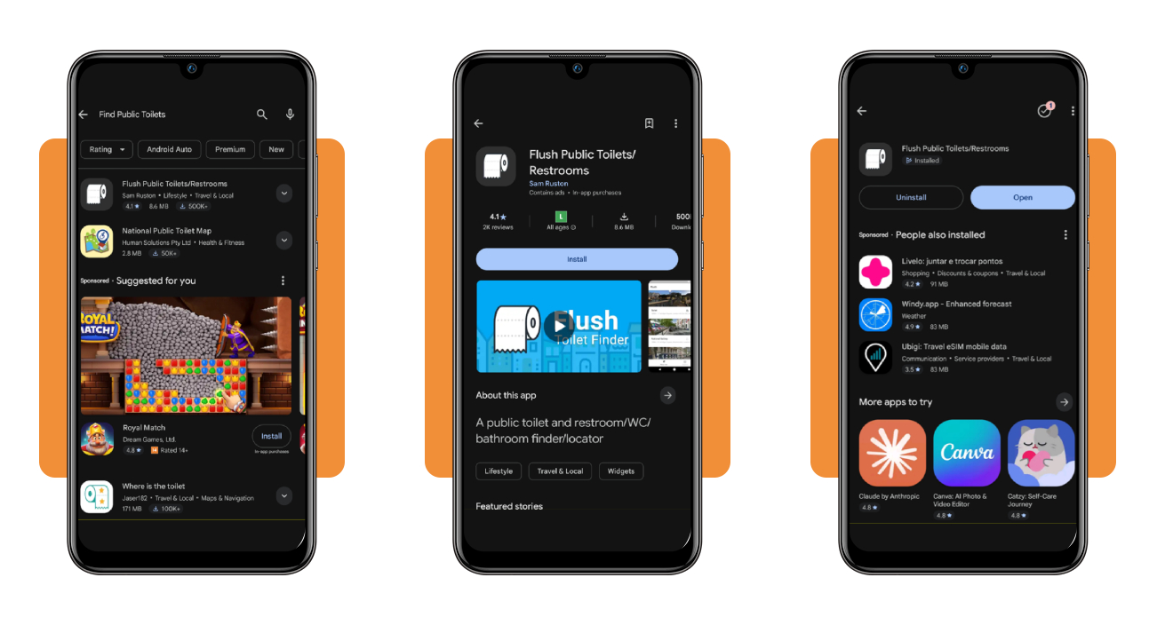
Step 1: download Flush on your device
Search the App Store for ‘Flush Toilet Finder & Map’ on your iPhone or iPad, or open Google Play and look up ‘Flush Public Toilets/Restrooms’ on your Android phone.
Confirm the developer is JRustonApps B.V. or Sam Ruston and that your OS is up to date, and check if you have 56.3 MB of storage for iOS and 8.6 for Android before installing the app.
Step 2: enable your location and explore the map
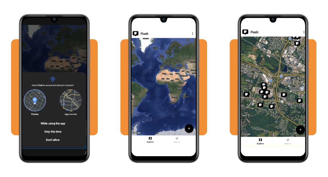
Open the app and answer the first location permission prompt by choosing the precise option and allowing access while you’re using the app, which lets the map center on your position.
The ‘Explore’ tab opens on a world view, and zooming in toward your region reveals black pins with a paper roll icon that help you locate public restrooms around you.
Step 3: find bathrooms near you and add new ones
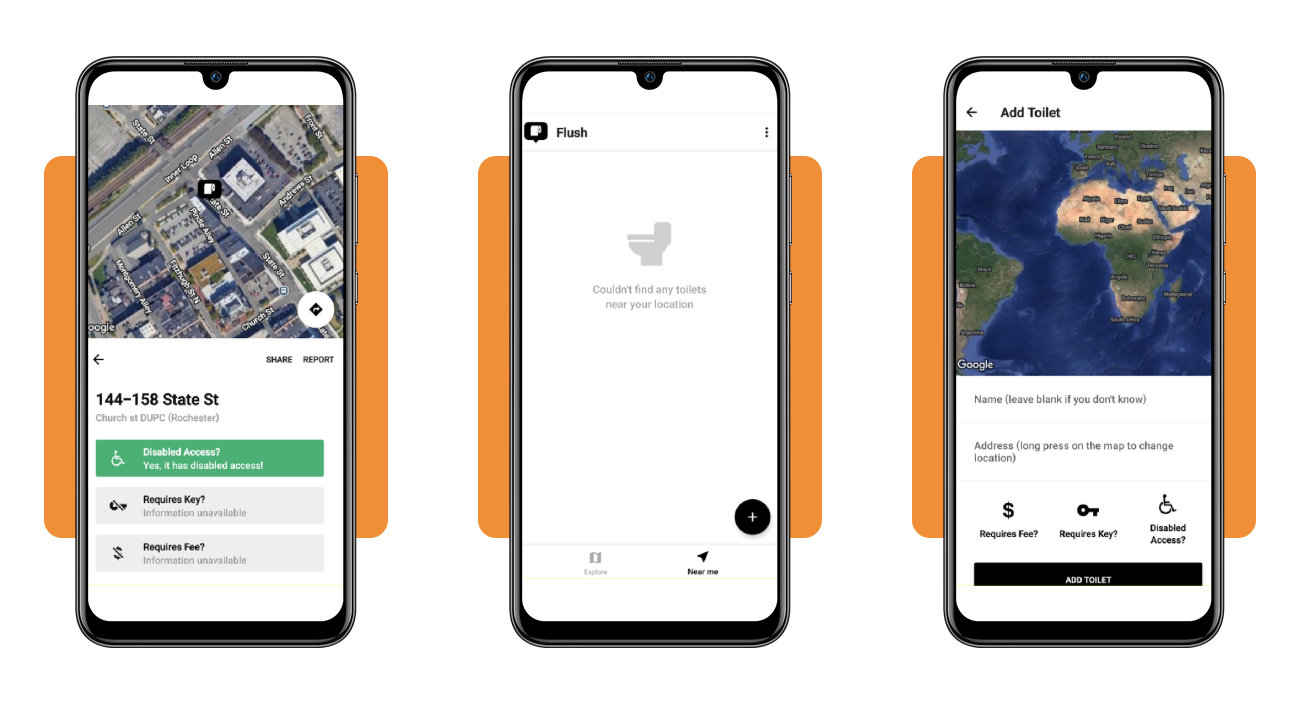
Tap ‘Near me’ for a list of the closest toilets or use the ‘Explore’ tab to drag the map toward the area you’re heading to. Whenever you find a bathroom, tap on it to see its details.
If Flush (Android | iOS) misses a restroom you’ve found, press the plus button, long-press the map to place the pin, flip the fee, key, or access toggles, and tap ‘Add Toilet’.
How to find restrooms during road trips
Rural highways can stretch for many miles between public restrooms, which is why you should begin your search at the first nudge instead of waiting until the need turns urgent.
A glance at a stop’s parking lot, lobby, and staff tells you plenty about its restrooms, and a pouch with sanitizer, wipes, and spare tissue covers whatever you find inside.
Flush (Android | iOS) handles the first search on a long drive, and pairing it with highway habits helps you locate public restrooms that are open, clean, and close to your next exit.
Stops along the route with dependable restrooms
Hotel lobbies, chain stores such as Target, Costco, and Home Depot, and coffee shops like Starbucks or Panera maintain their restrooms with care, and you can walk in without fuss.
State rest areas vary, but newer ones tend to stay in good shape and often include family restrooms, while hospitals, museums, and libraries offer quiet public restrooms you can use.
Exit guides and maps that show nearby options
iExit lists the gas stations, restaurants, and hotels waiting at upcoming interstate exits, which lets you pick an exit with a major brand you recognize before you leave the highway.
Google Maps shows posted hours, photos, and recent comments for each stop, and a search for ‘restroom near me’ helps you locate public restrooms before you commit to an exit.
Ask local staff and visitor centers for tips
Employees at coffee shops and small stores in town know which nearby restrooms stay open and well-kept, and a polite question often earns you directions to the best one.
Visitor center staff know which local restrooms deserve a visit, and a chat with another driver at a scenic overlook can point you to a good stop they just left.
Top mobile connectivity plans
Once you leave your home network, maps, live directions, and search results rely on mobile data, which makes your plan part of any restroom hunt that takes you across town.
Postpaid plans bill you at the end of the month for data and extras, while prepaid plans collect a fixed payment up front each month and add no surprise charges.
Check each carrier’s coverage map along your usual routes before you pick a plan, and you’ll locate public restrooms without a dead zone cutting your search short or stalling directions.
Verizon Simplicity for a single phone line
Verizon Simplicity costs $30 a month for unlimited 5G data and hotspot use, and Verizon reserves that price for lines you bring from another provider, with paid streaming add-ons.
Simplicity also texts through satellites when cell towers can’t reach you, though it offers no discount for extra lines and forces every line on your account to switch to it.
T-Mobile Essentials 2.0 for shared family lines
T-Mobile Essentials 2.0 charges $100 a month for 4 lines on one plan, and its 50GB of fast US data keeps maps ready when you need to locate public restrooms.
The plan supports up to 6 lines and covers unlimited calls, texts, and data in Canada and Mexico, though data there crawls at 2G while taxes and fees come extra.
US Mobile Unlimited Flex for low prepaid bills
US Mobile Unlimited Flex costs $17.50 a month for 1 line on prepaid billing; the sticker price covers all taxes and fees, and that lowest rate requires an annual purchase.
You pick the network, Verizon, AT&T, or T-Mobile, and get 10GB of fast data before speeds drop to 1Mbps, plus 5GB of hotspot data and a paid Multi-Network add-on.
4.7/5
Know where relief is before you need it
With Flush (Android | iOS) on your phone and a data plan that reaches where you travel, a sudden bathroom emergency turns into a short walk instead of a stressful search.
In this article, Insiderbits guided you through installing the app, picking a phone plan, and planning road trip stops that help you locate public restrooms in any town.
Keep exploring Insiderbits to read more articles about useful apps and resources to find reliable tools that work when you need them and save you time.