Le app di mappe online facilitano gli spostamenti. Vi aiutano a trovare i luoghi e i modi migliori per raggiungerli. Grazie a questi strumenti, sarete sempre sulla strada giusta, ovunque vi troviate.
Insiderbits vi propone un elenco delle migliori app di navigazione. Abbiamo scelto le migliori che sono facili da usare e vi portano dove dovete andare, rendendo ogni viaggio più agevole e senza preoccupazioni.
Ma le app GPS non sono solo indicazioni stradali! Possono trasformare viaggi ordinari in avventure emozionanti. Siete curiosi di saperne di più? Continuate a leggere per scoprire quali app sono state inserite nella nostra lista.
Correlato: Le migliori applicazioni GPS offline gratuite!
Citymapper

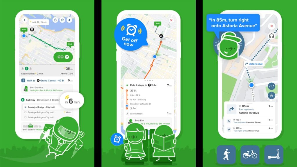
Citymapper brilla tra le app di mappe grazie alle sue opzioni di viaggio in tempo reale tra le diverse modalità di trasporto, semplificando la navigazione urbana per tutti.
Questa applicazione GPS è in grado di fornire indicazioni turnarie per i trasporti pubblici, gli spostamenti a piedi, in bicicletta e in scooter, per rendere la vostra esplorazione il più agevole possibile.
Citymapper combina il meglio delle app di navigazione, offrendo una pianificazione intelligente dei percorsi che include autobus, treni, traghetti e persino il ride sharing. È uno strumento completo all-in-one.
Oltre alle funzioni GPS standard, l'app si integra anche con servizi come Uber e Lyft, diventando così una soluzione di mobilità completa anche per quanto riguarda il ride sharing.
Con Citymapper è possibile superare le ore di punta monitorando in tempo reale i tempi di attesa e l'ETA di autobus, treni e traghetti, una funzione che non si trova nella maggior parte delle app simili.
Con Citymapper potete anche personalizzare i vostri spostamenti, salvando le destinazioni più frequenti e ricevendo aggiornamenti sui ritardi dei trasporti pubblici per pianificare la vostra giornata di conseguenza.
| Prezzi: | Gratuito, ma con supporto pubblicitario. È possibile rimuovere gli annunci per $1,49 al mese, oppure acquistare la versione premium priva di annunci con più funzioni per $9,99 al mese. |
| Disponibile per: | Android e iOS. |
I punti salienti di Citymapper
- Confronto dei viaggi in tempo reale: Citymapper confronta istantaneamente le varie opzioni di trasporto in tempo reale, distinguendosi dalle altre app di mappe.
- Indicazioni stradali: Offre una navigazione dettagliata, passo dopo passo, per i mezzi pubblici, gli spostamenti a piedi, in bicicletta e in scooter, migliorando il suo status tra le app GPS.
- Partnership con i servizi di mobilità: Collabora con Uber, Lyft, Lime e altri, consentendo agli utenti di chiedere passaggi, condividere biciclette o trovare facilmente scooter.
- Tempi di attesa e ETA in tempo reale: Visualizza in tempo reale i tempi di attesa di autobus, treni e traghetti, aiutando gli utenti a evitare la folla e i ritardi nelle ore di punta.
- Tracciamento del trasporto pubblico: Segue i trasporti pubblici in tempo reale sulla mappa, mostrando il vagone migliore per salire e quando scendere.
- Navigazione personalizzata: Gli utenti possono salvare le destinazioni più frequenti e abbonarsi a linee di transito specifiche per ricevere avvisi personalizzati di interruzioni e ritardi.
- Accesso offline: Fornisce l'accesso a mappe offline come la mappa della metropolitana di New York, la mappa della metropolitana di Washington e altre ancora, garantendo la navigazione anche senza accesso a Internet.
Gli intoppi di Citymapper
- Copertura geografica limitata: Citymapper non è disponibile in tutte le città, il che limita la sua utilità per gli utenti delle regioni non coperte dall'applicazione.
- Dipendenza dalla connessione a Internet: Sebbene offra mappe offline, le funzioni in tempo reale, come gli aggiornamenti in tempo reale e l'ETA, dipendono fortemente da una connessione a Internet.
- Interfaccia complessa: Gli utenti che si avvicinano per la prima volta a questa applicazione potrebbero trovare l'interfaccia e la moltitudine di funzioni eccessiva rispetto alle applicazioni di mappe più semplici.
- Consumo della batteria: Grazie al GPS e alle funzioni di tracciamento in tempo reale, Citymapper può consumare una notevole quantità di batteria, il che rappresenta un problema per i viaggi lunghi.
- Imprecisione nei dati in tempo reale: Occasionalmente, l'app può visualizzare dati imprecisi in tempo reale per il trasporto pubblico, portando a potenziali errori di valutazione nei piani di viaggio.
4.8/5
Correlato: Le migliori app per vedere la mappa della vostra città via satellite
Karta GPS

Karta GPS offre un'esperienza di navigazione unica e personalizzabile tra tutte le app GPS, con un tocco personale che consente agli utenti di scegliere voci divertenti e icone dei veicoli.
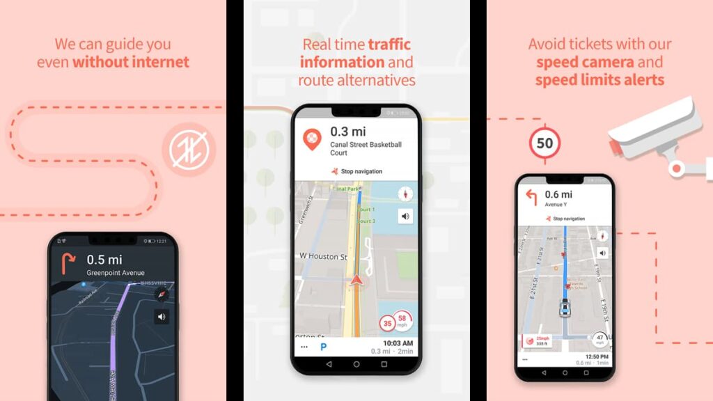
Una delle app di navigazione più popolari, Karta offre mappe gratuite e scaricabili per l'uso offline, garantendo indicazioni affidabili turn-by-turn anche senza una connessione a Internet.
L'app è nota anche per la sua attenzione alla sicurezza di guida, grazie agli avvisi di velocità e radar a vita, che la distinguono dalle altre app di mappe semplicemente perché mettono al primo posto il benessere dell'utente.
La funzione di traffico in tempo reale di Karta consente di evitare gli ingorghi, diventando così la scelta ideale per la navigazione in tempo reale quando si è di fretta.
Offrendo un'ampia varietà di POI (punti di interesse) come ristoranti e punti di riferimento, Karta GPS rende l'esplorazione di nuove aree facile e fresca, con attrazioni costantemente aggiornate.
Inoltre, grazie a funzioni come la ricerca vocale e l'assistenza al parcheggio, questo incredibile strumento semplifica la navigazione, rappresentando una soluzione completa per le app cartografiche.
| Prezzi: | Gratuito, ma contiene annunci. È possibile rimuovere gli annunci per $2,49 al mese e non esiste una versione premium. È anche possibile personalizzare l'applicazione con una serie di acquisti in-app a partire da $0,99. |
| Disponibile per: | Android e iOS. |
I punti salienti di Karta GPS
- Navigazione personalizzabile: Unica tra le applicazioni GPS, Karta GPS consente agli utenti di personalizzare la navigazione con varie voci e icone di veicoli divertenti.
- Accessibilità alle mappe offline: Mappe scaricabili per le località del mondo o per i singoli Stati degli USA, che consentono la navigazione offline senza bisogno di una connessione a Internet.
- Mappe stradali gratuite: Offre mappe OpenStreetMap (OSM) arricchite gratuitamente, una caratteristica di spicco nel panorama delle app di mappe, che garantisce l'accessibilità a tutti gli utenti.
- Avvisi di velocità e radar: Include aggiornamenti a vita per gli avvisi di velocità e radar, migliorando la sicurezza e la consapevolezza del conducente.
- Aggiornamenti sul traffico in tempo reale: Questa app di navigazione fornisce servizi di traffico in tempo reale per trovare percorsi più rapidi ed evitare gli ingorghi, fondamentali per gli spostamenti in tempo reale.
- Suggerimenti per i punti di interesse: Scoprite i ristoranti, i negozi, i monumenti e molto altro ancora nelle vicinanze con facili suggerimenti, rendendo l'esplorazione semplice e divertente.
- Reinstradamento automatico: Regola i percorsi in tempo reale al variare delle condizioni del traffico, una funzione fondamentale per viaggiare senza problemi.
Gli intoppi di Karta GPS
- Limited Features in Free Version: Alcune funzioni avanzate di Karta GPS, come gli aggiornamenti sul traffico in tempo reale, possono richiedere un abbonamento premium.
- Occasionali imprecisioni nelle mappe: Gli utenti hanno segnalato occasionali imprecisioni nelle mappe fornite, che possono causare errori di navigazione.
- Annunci nella versione gratuita: La presenza di annunci pubblicitari nella versione gratuita dell'applicazione può essere invadente, soprattutto se confrontata con le esperienze prive di annunci di altre applicazioni GPS.
- Scarico della batteria durante la navigazione: Come molte applicazioni basate sul GPS, Karta GPS può consumare molta batteria durante la navigazione attiva.
- Mancanza di elementi incentrati sui pedoni: L'app è pensata principalmente per gli automobilisti e potrebbe non offrire molti percorsi a piedi dettagliati o funzioni orientate ai pedoni.
4.4/5
Correlato: Le 5 migliori app per trovare le attrazioni nelle vicinanze
OsmAnd

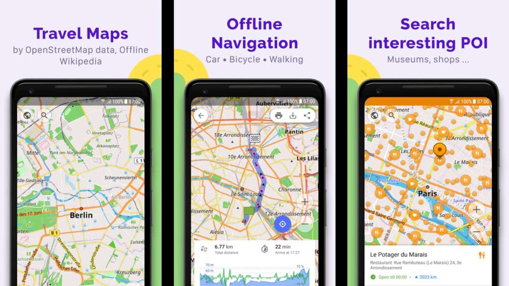
Infine, ma non certo per importanza, OsmAnd fornisce una navigazione offline dettagliata utilizzando i dati di OpenStreetMap, una caratteristica di spicco tra le app GPS per le aree remote.
Si tratta di una delle app di mappe più particolari, grazie alla sua attenzione alla privacy degli utenti e allo sviluppo open-source. Ciò significa che tutti i dati degli utenti sono protetti e che l'app è in costante miglioramento.
OsmAnd offre profili di navigazione versatili per auto, biciclette, pedoni e altro ancora, rendendola una scelta completa e conveniente nel mondo delle app di navigazione.
La pianificazione degli itinerari in OsmAnd è migliorata grazie a dati visivi come discese/ascensioni, ideali per gli amanti dell'outdoor per sfruttare al meglio le loro esplorazioni.
La capacità dell'app di apportare modifiche a OpenStreetMap e di ricevere aggiornamenti frequenti delle mappe distingue OsmAnd nel mondo delle app GPS, perché offre una precisione senza pari.
Inoltre, le funzioni avanzate di OsmAnd, come la bussola, il tema notturno e l'integrazione con Wikipedia, offrono un'esperienza più ricca rispetto alle app di navigazione standard presenti sul mercato.
| Prezzi: | È gratuito, ma sono previsti una serie di piani di abbonamento e acquisti in-app per ulteriori funzioni. È possibile abbonarsi al piano mensile a $2,99. |
| Disponibile per: | Android e iOS. |
I punti salienti di OsmAnd
- Accesso alla mappa del mondo offline: Utilizza OpenStreetMap (OSM) per la navigazione offline, distinguendo OsmAnd nelle app GPS category per le aree remote o non collegate.
- Focus sulla privacy degli utenti: Essendo un'applicazione open-source, dà priorità alla privacy degli utenti, non raccogliendo i loro dati, un aspetto unico tra le app di mappe.
- Profili di navigazione multipli: Offre profili personalizzabili per diversi veicoli come auto, biciclette e pedoni, migliorando la sua versatilità tra le app di navigazione.
- Pianificazione e registrazione del percorso: Consente la pianificazione dettagliata dei percorsi e la registrazione delle tracce GPX, completa di dati visivi su salite e discese.
- Integrazione OpenStreetMap modificabile: Gli utenti possono apportare modifiche a OSM e ricevere aggiornamenti frequenti delle mappe, una funzione che non si trova comunemente nelle applicazioni GPS standard.
- Navigazione GPS personalizzabile: Permette di tracciare percorsi senza internet, con opzioni per modificare i percorsi in base ai tipi di strada e alle dimensioni del veicolo.
- Strumenti e funzioni aggiuntive: Include una bussola, un righello a raggio, un tema notturno e l'integrazione con Mapillary e Wikipedia per un'esperienza di navigazione più ricca.
Il singhiozzo di OsmAnd
- Guida In-App limitata: L'applicazione non dispone di tutorial o guide complete all'interno dell'applicazione, il che può rendere la navigazione difficile per coloro che non hanno familiarità con il GPS.
- Problemi di prestazioni: Molti hanno segnalato sporadici crash dell'app e prestazioni lente, un problema non sempre presente in altre app di navigazione.
- Notevoli download di app e mappe: Le mappe offline possono essere di grandi dimensioni e richiedono uno spazio di archiviazione significativo, uno svantaggio rispetto ad alcune app di mappe più leggere.
- Limitazione delle funzioni a pagamento: Mentre OsmAnd offre molte funzioni gratuite, alcune opzioni avanzate come le guide di viaggio offline sono a pagamento.
- Pianificazione del percorso meno intuitiva: Il processo di pianificazione del percorso può essere meno intuitivo e richiedere più tempo rispetto ad altre app GPS semplificate.
4.5/5
Correlato: Le 5 migliori app per pianificare gli itinerari
Navigare sulle strade digitali: Le migliori applicazioni cartografiche svelate
In questo articolo abbiamo esplorato diverse app di mappe, ognuna delle quali offre caratteristiche uniche per la navigazione e la localizzazione GPS, dalle funzionalità offline agli aggiornamenti in tempo reale sul traffico.
Che si tratti di pianificare un percorso o semplicemente di trovare la strada più veloce per arrivare a destinazione, queste app di navigazione offrono soluzioni che possono rendere il viaggio più efficiente per tutti.
Se vi è piaciuta la nostra guida, seguiteci su Insiderbits per altre scoperte tecnologiche. Dalle app più recenti ai gadget più interessanti, abbiamo le informazioni necessarie per farvi conoscere il mondo della tecnologia!


