

Planning a trip to a national park means piecing together maps, murky trail info, and spotty cell service once you arrive. The official NPS app puts every detail into your hands before you leave.
Le présent Idées reçues guide explains how to download and use the app, how to make the most of it, plus a few tips on which national parks to visit first. Your next outdoor escape awaits. Read on!
En rapport : National Park Service: maps and guided tours of 400+ US national parks

4.9/5
Understanding how the official NPS app works
Every trip into a national park calls for solid information, and a single download brings it all together in one place, made for wandering adventurers like you.
The National Park Service app (Android | iOS) connects you to trail maps, ranger-led tours, and real-time alerts, turning your phone into a pocket-sized guide wherever your hike leads you.
From remote overlooks to bustling visitor centers, the official NPS app keeps every detail close at hand, helping you plan routes and enjoy every visit until the very last second.
Features available in the official app
- Interactive maps: see trail layouts, points of interest, and boundaries laid out well, letting you plan a route that fits your pace and interests;
- Self-guided tours: walk through park highlights at your pace, following stops that reveal history, wildlife, and scenery like a ranger walked beside you;
- Amenities and visit planning: find restrooms, dining spots, transportation options, fee details, and operating hours, gathered to help you prepare for each outdoor trip;
- Passport stamps and daily alerts: track visited parks, collect digital stamps, and stay informed on news, closures, and events without constantly searching multiple websites.
Offline access for remote adventures
Cell service fades quickly once trails wind deeper into forests, canyons, and mountain passes, leaving you without a reliable way to check details right on the spot.
Downloading content ahead of a hike solves that concern, and the official NPS app lets you save maps, park lists, and points of interest for full offline use.
Accessibility options for every visitor
Not every visitor experiences a park the same way, and the NPS’s thoughtful design makes sure no one gets left out of the wonder waiting inside these wild protected lands.
Audio descriptions guide visitors through exhibits and points of interest, giving people with visual impairments a rich, detailed sense of each remarkable site’s full story, history, and surroundings.
Step-by-step guide to installing and using the free app
Installing the National Park Service app (Android | iOS) takes less than a minute, and once it’s ready, your phone becomes a reliable companion for exploring trails and landmarks nationwide.
Anyone new to visiting national parks earns an edge from a clear walkthrough, especially when heading into unfamiliar territory where signal drops and printed brochures fall short.
Every device works a little differently, but the process stays fairly simple across phones and tablets, walking you through each part of setting up the official NPS app.
Step 1: download the app on your device
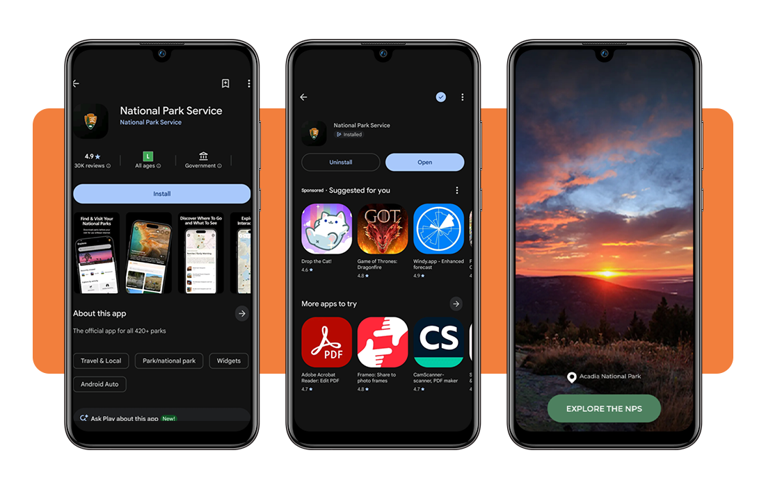
Ouvrir le App Store ou Google Play, search for ‘National Park Service’, and tap ‘Get’ or ‘Install’ to bring information on over 420 parks straight onto your phone or tablet within seconds.
Once installation finishes, open the icon and grant location permission so nearby parks and points of interest show up right away on your home screen.
Step 2: search or browse for a park
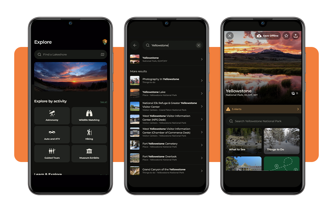
Type a park name directly into the search bar, or browse through listings by state, activity, or category when a destination hasn’t been decided just yet.
Each result opens into a detailed page packed with maps, alerts, things to do, and photos that help paint a fuller picture of that particular park location instantly.
Step 3: save maps for offline use
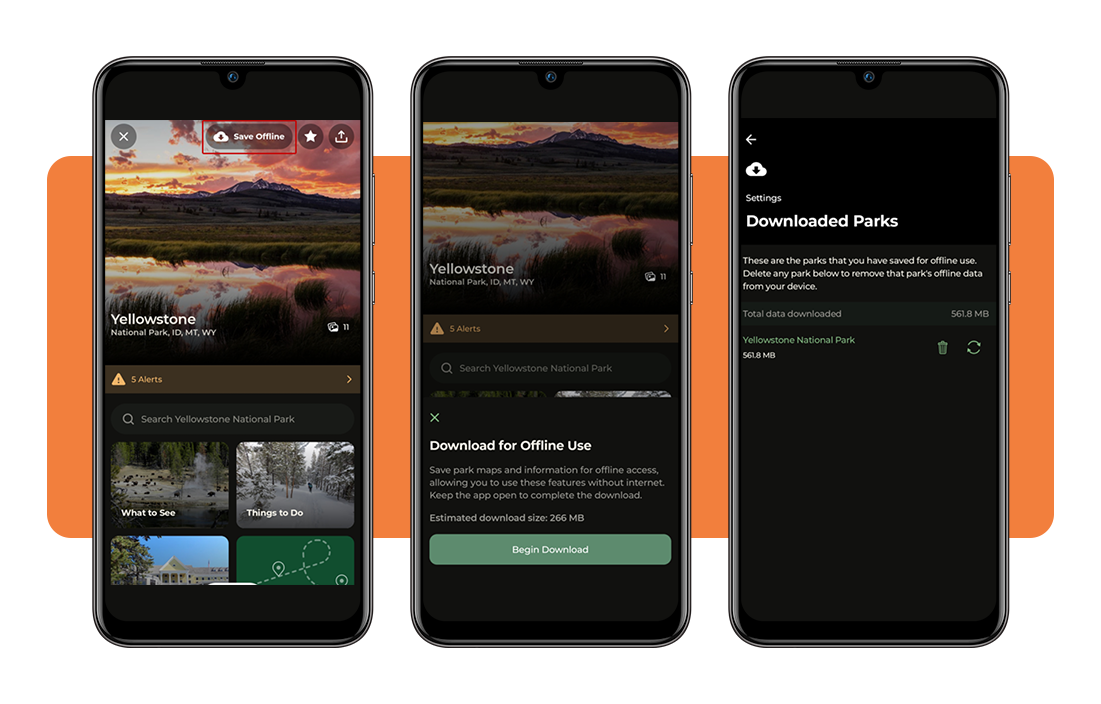
Before heading out somewhere remote, tap the cloud icon on any park page, and the official NPS app stores maps and details for later use without a signal.
Saved content stays put even in areas with zero connection, giving you and your family full access to trail data, points of interest, and nearby amenities on the go.
En rapport : Find Free RV Parking and Overnight Spots With This App
How to explore the map of local parks
Every park holds a network of trails, overlooks, and landmarks scattered across large stretches of land, and a detailed map helps you make sense of it all.
Instead of scrolling through long lists, tapping into a visual layout lets you spot nearby landmarks, trailheads, and visitor centers without losing track of where everything sits.
Zooming into a region reveals clusters of numbered pins representing monuments, historic sites, and other landmarks, and the official NPS app organizes them by proximity and category.
Search for a specific park
Instead of scrolling through the full list, typing a location narrows the map down right away, centering the view on that exact park and its surrounding boundaries.
Nearby landmarks, trailheads, and visitor centers appear as pins around that spot, giving you a sense of scale and proximity before diving into a single destination further.
Tap points of interest on trails
Numbered pins across a trail represent geysers, overlooks, historic buildings, and other landmarks worth a stop, each one revealing photos and details once selected.
Tapping any marker opens a short description along with images, showing a preview of what waits ahead before committing time and energy to reaching that spot.
Filter parks by type or activity
Browsing becomes far more manageable once results are narrowed down by category, letting you sort through monuments, historic sites, memorials, and parks based on personal interest.
Filtering further by state, activity, or topic brings up options like hiking, wildlife watching, or astronomy, matching destinations to whatever kind of outdoor experience you’re after.
Most popular national parks in the United States
Out of over 420 sites managed nationwide, a handful of options draw crowds every single year thanks to landscapes that feel almost impossible to capture through a single photograph.
These destinations combine natural wonders, wildlife sightings, and breathtaking views, pulling travelers from every corner of the country toward experiences that stick with them for years.
Each park brings something distinct to the table, and browsing through the official NPS app (Android | iOS) helps you compare options before settling on a first or next destination.
Yellowstone and its iconic geysers
Bubbling hot springs, roaring geysers, and free-roaming bison make this park feel like stepping onto a different planet within the United States.
Old Faithful draws crowds for its predictable eruptions, while surrounding trails lead visitors past colorful pools and steaming vents scattered across a volcanic landscape unlike anywhere else.
- Location: spanning parts of Wyoming, Montana, and Idaho, this park sits atop one of the largest active volcanic systems found anywhere on Earth;
- Why it’s popular: geothermal features paired with abundant wildlife create a rare combination that keeps this park near the top of every traveler’s list.
Yosemite’s granite cliffs and waterfalls
Towering granite walls rise straight out of the valley floor, framing waterfalls that thunder down during peak snowmelt season each spring and early summer.
Rock climbers travel from around the globe to attempt routes up El Capitan, while hikers wander beneath giant sequoias that stand taller than most buildings in cities.
- Location: tucked into the Sierra Nevada mountain range in central California, this park spreads across roughly 1,200 square miles of protected wilderness;
- Why it’s popular: thrilling cliff faces paired with some of the tallest waterfalls in North America draw both casual visitors and serious climbers.
Grand Canyon’s vast desert views
Layers of red rock stretch for miles in every direction, revealing millions of years of geological history carved out by the Colorado River below.
Sunrise and sunset transform the canyon walls into shifting shades of orange and purple, drawing photographers to overlooks spaced out along both rims of the park:
- Location: sitting entirely within Arizona, this canyon stretches 277 miles long and reaches depths of over a mile in certain sections;
- Why it’s popular: sheer scale paired with striking color changes throughout the day makes this canyon one of the most photographed places in the world.
En rapport : Voir les cartes GPS en direct de l'ensemble des États-Unis
4.9/5
Pack this app for every park visit
A bison crossing a road in Yellowstone or a beautiful waterfall roaring through Yosemite hits different when you already know what’s waiting up ahead.
In this article, Idées reçues covered how to download the official NPS app, hunt down specific parks, and save trail maps before losing signal out there.
Save Idées reçues to your favorites and check back for more reviews and guides on apps built for chasing waterfalls, tracking wildlife, and planning your next hike.